Cavan Burren Park: Megalithic Landscapes in the Hidden Heartlands
Cavan Burren Park sits in a quiet corner of northwest Cavan, just outside Blacklion on the N16 between Sligo and Enniskillen. It is part of the UNESCO Marble Arch Caves Global Geopark, straddling the Cavan-Fermanagh border. Entry is free and the park is open year-round.
What you find here is one of Ireland's most concentrated prehistoric landscapes. Over 80 monuments are recorded within the park boundaries - wedge tombs, stone circles, rock art, ringforts, and glacial erratics scattered across a limestone plateau that has been shaped by ice, water, and human hands over thousands of years.
People often compare it to the Burren in County Clare, and the geological family resemblance is real. This is the northern counterpart: smaller, quieter, and far less visited. If you are interested in early Irish history or just want a walk that feels genuinely different from the usual Irish forest trail, Cavan Burren earns a half-day on any itinerary in this part of the country.
Five looped walking trails cover more than 10 kilometres across the site, ranging from a short 1km loop to a 3km route. One trail has multi-access surfacing. The visitor centre has exhibits, maps, toilets, and picnic areas. Guided tours can be booked through the park.
What to Expect
The park is built around five looped trails, each named for a feature along the route. The shortest is around 1km and takes 20 to 30 minutes. The longest is approximately 3km and takes about an hour at a comfortable pace. Signage throughout is clear and the paths are well maintained, mixing gravel surfaces with boardwalk sections where the ground gets soft.
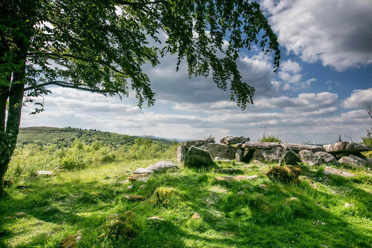
The Calf House Dolmen Trail is the most visited route. It brings you directly to the park's most famous monument - a wedge tomb known locally as the Calf House Dolmen. The capstone is enormous, balanced on two upright stones in a way that still looks improbable after five millennia. This trail is also the one with multi-access surfacing, so it works for pushchairs and wheelchairs. The Giant's Leap Trail takes you to the Giant's Grave, a long cairn on higher ground with views across the plateau. The Tullygobban Lough Trail loops out toward the lake, though it is worth knowing that the water is largely screened by reeds and you will not get much of a view from the trail itself.
Across all the routes you will encounter glacial erratics - boulders carried here by ice around 13,000 years ago and dropped wherever the glacier stalled. Some are the size of small cars, sitting at odd angles on the limestone pavement. The rock underfoot dates to the Carboniferous period, roughly 340 million years old, and the karst features are visible throughout: sinkholes, fissures, and sunken valleys carved by water working through the limestone over millennia.
The Neolithic monuments are spread across the whole site and many are off the main path. The promontory hill fort in particular can be difficult to locate without the trail map from the visitor centre - worth picking one up before you set out. Some of the information panels in the park show signs of weathering and the text is not always easy to read. That is a minor frustration on an otherwise well-run site.
The plateau is exposed. There is no tree cover on the upper sections and the weather changes quickly this close to the Atlantic. Wear layers even in summer and assume the trails will be soft underfoot after rain. Sturdy footwear is more useful here than a light pair of trainers.
The visitor centre has a worthwhile exhibition covering the geology, archaeology, and ecology of the geopark. It puts the monuments in context and is worth 20 minutes before you walk. Guided tours are available and can be booked through the park - a good option if you want the history explained on the ground rather than read from a panel.
How to Get There
Cavan Burren Park is off the N16, the main road between Sligo and Enniskillen. The entrance is signposted from the road near Blacklion village. The approach lanes are narrow in places, so take your time on the final stretch. The car park is free and large enough to handle a busy summer day without queuing.
By car, the park is about 1 hour 40 minutes from Dublin via the N3 and N55, or around 50 minutes from Sligo town on the N16. From Enniskillen across the border it is a 20-minute drive. If you are combining the visit with Marble Arch Caves, that site is roughly 20 minutes away on the Fermanagh side.
Public transport to Blacklion is limited. Bus Eireann serves the Sligo-Enniskillen corridor but schedules are infrequent. Most visitors arriving without their own transport will find it easier to base themselves in Sligo or Enniskillen and hire a car for the day.
The park is close to the border, so Northern Ireland driving rules apply once you cross into Fermanagh. There are no border checks on this route but keep that in mind if you are planning a combined day that takes in Marble Arch Caves.
Where to Stay Nearby
Blacklion sits on the doorstep of the park and has accommodation options at both ends of the budget range. Enniskillen, 30 minutes into Northern Ireland, adds more choice if you are spending a couple of days in the area. Book MacNean House well in advance - it is one of the most in-demand restaurant-with-rooms in Ireland.
Neven Maguire's celebrated restaurant with rooms in the centre of Blacklion. The food is the reason most people come - the rooms mean you do not have to drive home afterwards.
Check availability →What Else is Nearby
A Note on the History
The limestone bedrock beneath the park formed around 340 million years ago during the Carboniferous period, when this part of Ireland lay under a shallow tropical sea. Glaciers arrived much later - around 13,000 years ago - carrying boulders from distant rock formations and depositing them across the plateau as the ice retreated.
The Neolithic monuments came later again. The wedge tombs, stone circles, and rock art date to roughly 4,500 to 5,000 years ago, placing them in the same broad period as Newgrange and the megalithic sites of the Boyne Valley. Over 80 recorded monuments make this one of the densest concentrations of prehistoric archaeology in Ireland.
The park sits within the UNESCO Marble Arch Caves Global Geopark, a designation that recognises the geological significance of the landscape on both sides of the Cavan-Fermanagh border.
Frequently Asked Questions