Moneygashel Cashel, County Cavan
Moneygashel Cashel sits on the lower slopes of Cuilcagh Mountain in west County Cavan, inside the Cuilcagh Lakelands UNESCO Global Geopark. It is one of the most significant early medieval stone monuments in southern Ulster - three concentric rings of dry-stone walling enclosing the remains of a fortified settlement that would have been occupied roughly between the 5th and 10th centuries AD.
You reach it by a short walk from a rural trailhead off Cornagee Road, near the village of Blacklion. The surrounding landscape is karst limestone, blanket bog, and drumlins - classic Cavan terrain that has changed very little since those stone walls were first raised.
This is not a managed heritage attraction in any conventional sense. There is no visitor centre, no entrance fee, no tearoom. What you get is an ancient monument in its actual landscape, largely undisturbed. That is both its appeal and its challenge. If you go in, go prepared.
What to Expect
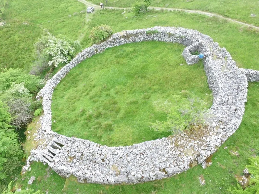
The cashel is described by archaeologists as the finest of its kind in southern Ulster. Three concentric stone walls, each built without mortar, step outward from a central enclosure. The inner ring is the most substantial. Settlement remains survive inside - outlines of structures that would have sheltered people, animals, and whatever needed protecting in early medieval Cavan.
The setting is part of what makes Moneygashel unusual. You are standing inside a UNESCO Global Geopark, on a limestone landscape shaped by glaciation and karst processes. The Cuilcagh mountain rises behind you. Blanket bog stretches in every direction. On a clear day the scale of this part of the border region becomes very apparent. On a grey day it can feel exposed and isolated.
That isolation is something to account for before you go. The site is genuinely difficult to locate without prior knowledge. There is limited signage on approach, and the trailhead is not prominently marked. Several visitors report arriving in the general area and struggling to find the correct access point. A GPS track or a guide helps enormously here.
Guided tours are available through Geopark Guide Dani, who operates from Cornagee Road. Booking through the Geopark is the best way to arrange this. The guided option is not just convenient - it adds significant context to what you are looking at.
Wear boots. The ground between the trailhead and the cashel is rough and boggy even in dry conditions. After rain it becomes considerably worse. The path itself may be overgrown in summer, particularly later in the season. There is no shelter at the site. If weather turns while you are out there, you are exposed.
None of this should put you off. Moneygashel is the kind of site that rewards some effort. You will not share it with a coach party. You will not queue to get in. What you will have is an early medieval ringfort, a UNESCO landscape, and very little between you and both of those things.
How to Get There
Moneygashel Cashel is accessed from Cornagee Road, off the R206 near Blacklion in west County Cavan, close to the border with County Fermanagh. Blacklion is the nearest village and sits roughly 5 kilometres from the trailhead.
By car from Dublin, the most direct route is the N3 north to Belturbet, then west on the R200 and R202 through Bawnboy and Swanlinbar towards Blacklion. Total drive time from Dublin is around 2 hours 15 minutes to 2 hours 30 minutes depending on traffic.
From Belfast, take the A4 west to Enniskillen, cross into the Republic at Belcoo/Blacklion, and turn left into Blacklion village. The drive from Belfast is approximately 1 hour 30 minutes.
There is no public transport serving the trailhead. For most visitors, this is a car-only destination. Use Google Maps or a GPS track to navigate to the trailhead precisely. The final approach on Cornagee Road is narrow and rural.
Where to Stay Nearby
Blacklion is the closest village to Moneygashel and has a small number of accommodation options. For a wider choice, Enniskillen in County Fermanagh is 30 minutes north and has everything from budget guesthouses to five-star lakeside hotels.
Neven Maguire's celebrated restaurant with rooms in the centre of Blacklion. The cooking is the reason most people come, but the rooms are comfortable and the location puts you five minutes from the Geopark.
Check availability →What Else is Nearby
A Note on the History
Moneygashel Cashel dates from the early medieval period, broadly spanning the 5th to the 10th century AD. A cashel is a stone-walled ringfort - the fortified equivalent of the earthen raths found across much of Ireland, built where stone was available and earth was not.
What makes Moneygashel exceptional is the triple-ring construction. Most ringforts have a single enclosing boundary. A double ring is less common. Three concentric walls, each carefully laid in dry stone without mortar, is rare - and on this scale, archaeologists consider it the outstanding example of its type in southern Ulster.
The interior enclosures would have contained a farmstead: a dwelling, animal housing, food storage, and the working structures of an early medieval household. The outer walls were defensive but also symbolic. A triple-ringed cashel signalled status and resources.
The site sits within the Cuilcagh Lakelands UNESCO Global Geopark, a designation that recognises both the geological and cultural heritage of this cross-border landscape.
Frequently Asked Questions