Beaghmore Stone Circles: Bronze Age Patterns on Open Bogland
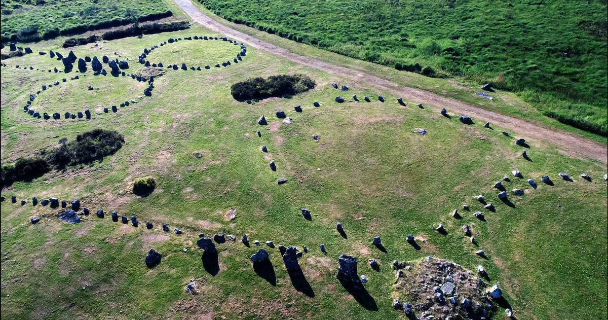
Beaghmore Stone Circles is a complex of seven stone circles, stone rows, and cairns on the southeastern edge of the Sperrin Mountains in County Tyrone. Peat cutters stumbled across the first stones in the 1930s. Excavation revealed over 1,269 stones arranged in patterns that date to the Bronze Age - roughly 2000 to 1200 BC.
The site is free, open 24 hours, and almost always deserted. No ticket office. No cafe. No guide. Just you and 4,000 years of silent stone on open bogland. That absence of infrastructure is part of the appeal. There is nothing between you and the Bronze Age except grass and sky.
Most visitors come here as a side trip from Cookstown or Omagh, and it pairs well with the Ulster American Folk Park or a day in the Sperrins. The drive out is on narrow roads through empty countryside, and when you arrive there is nothing to announce the site except a small car park and a gate. The stones are 50 metres from the road.
What to Expect
You park in a small gravel car park off a single-track road and walk through a gate. The stone circles are immediately visible - low stones arranged in clusters across a flat, boggy field. There is an interpretation board at the entrance but no other facilities. No toilets. No shelter. No bins.
The complex covers about a hectare. Seven stone circles sit alongside ten stone rows that radiate outwards and twelve cairns - small burial mounds. The stones are low, none higher than knee height, and many are barely visible above the grass. This is not Stonehenge. There is no dramatic vertical impact. The scale is horizontal - patterns spreading across the bogland that only reveal themselves as you walk through them.
The alignments may be astronomical. Some stone rows point towards the midsummer sunrise, others towards the midwinter sunset. The evidence is debated among archaeologists, but the alignments are precise enough that coincidence seems unlikely. Stand in the centre of the largest circle and look along the stone rows. Whatever the builders intended, they were paying close attention to the sky.
The atmosphere depends entirely on when you visit. On a still morning with mist sitting in the valleys, Beaghmore feels ancient and slightly unnerving. On a wet Tuesday afternoon in November, it feels bleak and exposed and you will want your waterproofs. On a sunny summer day, it is a pleasant spot for a slow walk with no urgency at all.
The honest negative: there is genuinely nothing here beyond the stones. No cafe within walking distance. No toilets. Limited parking - perhaps six cars. If you arrive and the car park is full (rare, but possible on a bank holiday), there is nowhere to overflow. The access road is single-track with passing places. And the site is exposed to weather from every direction. If rain moves in, you are getting wet - there is no shelter between you and the car.
Dogs are welcome but must be on leads. The ground is uneven and boggy in places, particularly after rain. Wellies or waterproof walking boots are advisable. The walk from the car park to the furthest stone circle takes about 10 minutes at a slow pace. You can see everything in 30 to 45 minutes, though lingering is the point.
How to Get There
Beaghmore is about 14 kilometres northwest of Cookstown, off the A505 road. From Cookstown, head west on the A505 towards Omagh. After about 15 minutes, take the signposted right turn. A narrow single-track road runs about 6 kilometres to the site. The road is tarmac but barely wide enough for two cars - use the passing places.
From Omagh, the drive takes about 35 minutes via the A505 east towards Cookstown, then the same single-track turn-off. From Belfast, allow about 1 hour 20 minutes via the M1 to Cookstown, then the A505. From Derry, about 1 hour 15 minutes via the A6 to Cookstown.
There is no public transport to Beaghmore. You need a car. The car park is small - space for about six vehicles - with no overflow. Arrive early on bank holidays or summer weekends. Most of the time, you will be the only car there.
Where to Stay Nearby
Cookstown and Omagh are the nearest towns with accommodation. Cookstown is closer at 15 minutes. See the County Tyrone guide for full accommodation options across the county.
In Cookstown town centre, 15 minutes from Beaghmore. The nearest proper hotel. Rooms from around £85 per night.
Check availability →What Else is Nearby
A Note on the History
The stones were hidden under peat for centuries. When local turf cutters began stripping the bog in the late 1930s, they uncovered the first circles. Excavation through the 1940s and 1960s revealed the full extent of the complex - seven circles, ten rows, and twelve cairns. Beneath the peat, archaeologists found Neolithic hearths and flint tools dating to 2900-2600 BC, suggesting the site was occupied long before the circles were built.
The circles themselves date to the earlier Bronze Age, roughly 2000 to 1200 BC. What they were for is not definitively known. The astronomical alignments are suggestive - several rows point towards solstice positions - but no single theory explains the full layout. The site may have served different purposes across the centuries of its use.
Only part of the complex has been excavated. More stones almost certainly lie under the surrounding peat. What you see today is the visible fraction of a larger landscape that once stretched across this section of the Sperrin foothills. The bogland preserved the stones perfectly. Ironically, the same conditions that hid them for centuries also protected them from being robbed for field walls or road building.
Frequently Asked Questions