Carrick-a-Rede Rope Bridge: What to Know Before You Cross
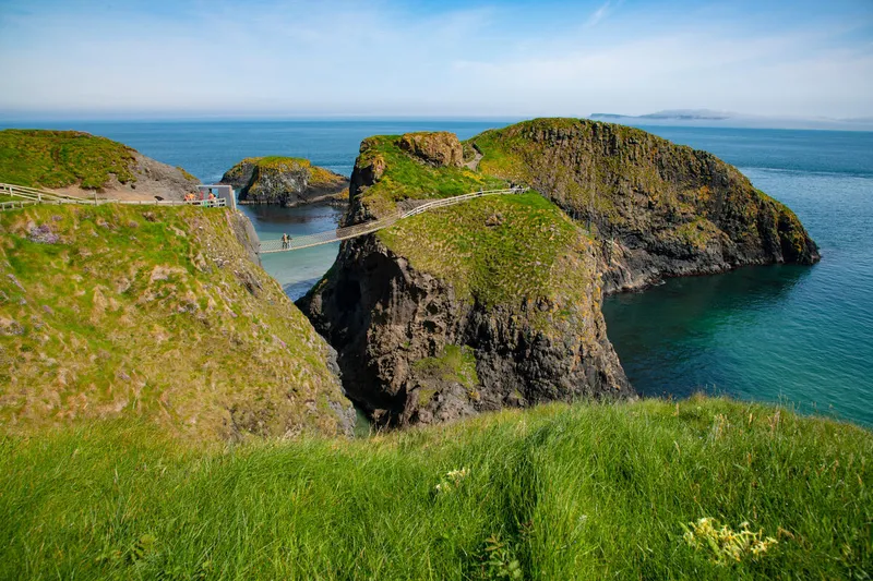
Carrick-a-Rede is a 20-metre rope bridge connecting the mainland to a tiny island off the north Antrim coast. Salmon fishermen first strung a bridge here 350 years ago. The current version is sturdier but still sways in the wind. The crossing takes 30 seconds. The queue to cross can take considerably longer.
The bridge gets the attention, but the real attraction is the walk to reach it. A one-kilometre coastal path from the car park crosses cliff-top grassland with views along the Antrim coast. The island itself is tiny - 10 minutes to explore - but the setting is dramatic. Sea stacks, nesting seabirds, and Scotland visible on a clear day.
What to Expect
The walk from the car park to the bridge is about one kilometre on a gravel path. It follows the cliff edge with views east toward Rathlin Island and west toward the Causeway headlands. In spring and summer the grassland is full of wildflowers and seabirds nest on the cliffs below.
The bridge itself is a simple rope construction with wire handrails and mesh flooring. It spans a 20-metre gap with a 30-metre drop to the sea. The crossing takes about 30 seconds. The bridge sways - not violently, but enough that you feel it. Looking down through the mesh at the water below is the moment most people either laugh or grip the handrails tighter.
The island, Carrickarede, is tiny. A loop path takes you around it in 10 minutes. There are the remains of a salmon fishery - the bridge was originally built so fishermen could check their nets. The views back to the mainland cliffs are excellent. Then you cross the bridge again to return.
The honest negative: if you have any fear of heights, the bridge is genuinely frightening and the crossing is not worth the stress. The queue to cross can also be long in summer - 30 minutes or more in peak season. You pay for a timed slot but still queue at the bridge itself. The island is small enough that the whole experience can feel rushed when it is busy.
How to Get There
Carrick-a-Rede is about 1 hour 15 minutes from Belfast, off the B15 near Ballintoy. It is 10 minutes east of the Giant's Causeway along the coast road.
The 172 bus from Coleraine stops nearby. Most day tours from Belfast to the Causeway coast include a stop here. A car lets you combine it with the Causeway, Dunluce Castle, and the Dark Hedges at your own pace.
Where to Stay Nearby
Ballintoy is the closest village but has limited accommodation. Bushmills and Ballycastle are both within 15 minutes and offer more choice. The County Antrim hub has the full picture.
B&B overlooking White Park Bay, one of the finest beaches on the Antrim coast. Peaceful, personal, and perfectly positioned between the Causeway and Carrick-a-Rede.
Check availability →What Else is Nearby
A Note on the History
Salmon fishermen first strung a rope bridge to Carrickarede island around 350 years ago. The salmon run along the north Antrim coast was once one of the richest in Ireland, and the island's position made it ideal for setting nets. The fishermen crossed on a single rope with wide gaps in the slats - far more terrifying than today's version.
The fishery closed in 2002 as Atlantic salmon numbers declined. The National Trust took over management and rebuilt the bridge as a visitor attraction. The original purpose is remembered in information boards on the island.
Frequently Asked Questions