Slieve Foye Loop Walk: Louth's Best Half-Day Hike
Slieve Foye is the highest point on the Cooley Peninsula at 589 metres, and the loop walk from Carlingford village is the best half-day hike in County Louth. It is free, takes 2-3 hours, and the views from the top - Carlingford Lough below, the Mourne Mountains across the water, Dundalk Bay to the west - are genuinely spectacular.
This is a proper hill walk, not a paved path. Moderate difficulty means you need hiking boots, a waterproof layer, and enough sense to check the forecast. But you do not need to be an athlete. Anyone with reasonable fitness and the right footwear will manage it fine.
What to Expect
The loop starts from a small car park above Carlingford village, signposted from the main street. The trail climbs through farmland and gorse before reaching open moorland. The first 30 minutes are the steepest - after that the gradient eases as you traverse the mountain flank.
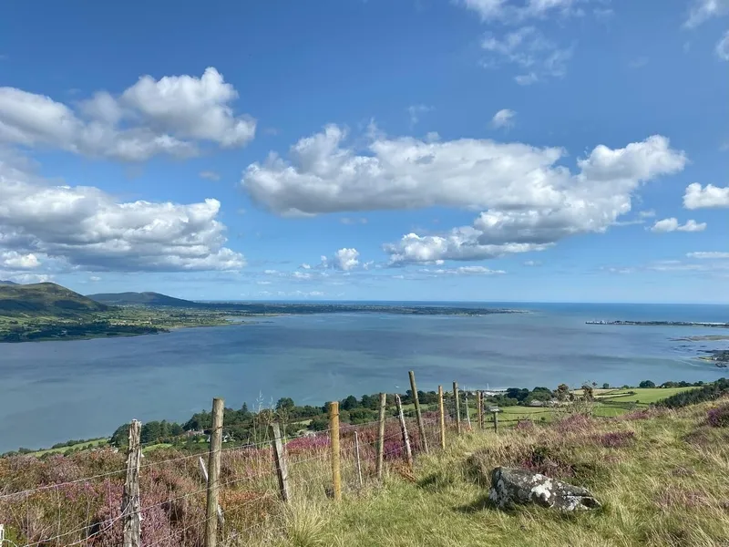
The views open up quickly. Carlingford Lough fills the gap between the Cooleys and the Mournes, with the village below looking like a model. On a clear day you can see from Dundalk Bay in the west to the Irish Sea in the east. The Mourne Mountains across the water are close enough to pick out individual peaks.
The summit at 589 metres is marked by a cairn. It is not dramatic - a broad, boggy plateau rather than a rocky peak - but the panorama is the reward. On a still day the silence is total. You can sit up there and see nothing man-made except Carlingford far below and a few farmhouses.
The descent loops back around the eastern side of the mountain, dropping through forest before emerging above the village. The full loop is about 10 km. Trail markings are adequate but not always obvious on the open mountain - keep the lough on your right on the way up and you will not go wrong.
The honest negative: this is an exposed mountain walk. In cloud, the summit plateau is featureless and navigation is tricky without experience. In rain, the boggy sections become genuinely soggy and the steep descent is slippery. The trail markings fade on the open mountain. If the forecast is poor, save it for another day and walk the coastal path in Carlingford instead.
How to Get There
The trailhead is above Carlingford village, signposted from the main street. If you are driving to Carlingford from Dublin, it is 100 km via the M1 and R173. Park at the trailhead car park or in the village and walk up.
There is no public transport to the trailhead. A car is essential. Most walkers combine Slieve Foye with lunch in Carlingford afterwards - the pubs and restaurants are the perfect recovery stop.
Where to Stay Nearby
Carlingford at the foot of the mountain is the obvious base. Walk down after the hike and reward yourself.
Georgian house with castle tours and local food tastings. The cooking school is worth booking even if you don't stay. Best accommodation in Louth.
Check availability →What Else is Nearby
A Note on the History
Slieve Foye features in the Tain Bo Cuailnge as part of the landscape Cu Chulainn defended against Queen Maeve's army. The mountain and the Cooley Peninsula are the heartland of the story. The Tain Way walking trail that crosses the mountain is named for the epic.
The mountain has been grazed by sheep for centuries. The lower slopes were planted with forestry in the 20th century - the descent route passes through this plantation. The summit has never been built on or significantly altered. It is one of the few high points in Louth that looks much as it would have a thousand years ago.
Frequently Asked Questions