Military Road & Sally Gap: Wicklow's Mountain Drive
The Military Road is a 56-kilometre route through the Wicklow Mountains that starts in the Dublin suburbs and climbs into a landscape of blanket bog, heather, and peat-dark lakes. The British army built it after the 1798 rebellion to flush out Irish rebels who were using the mountains as cover. It worked militarily and accidentally created one of the best driving routes in Ireland.
Sally Gap is the crossroads at the highest point, where the Military Road meets the R759. This is where you stop, get out, and look around at a landscape that feels nothing like the city 30 kilometres away. Lough Tay - the Guinness Lake, so called because the Guinness family owns the estate and the dark water against the white sand beach looks like a pint - is the most photographed viewpoint. But the whole drive is the point, not just one stop. County Wicklow is called the Garden of Ireland, but up here it is all moorland and sky.
What to Expect
The route starts unassumingly at Rathfarnham on the southern edge of Dublin. Within 15 minutes you are climbing through forest into open moorland. The city disappears behind you and the landscape opens into rolling bogland with not a building in sight. It happens fast and the contrast is startling if you have just left the traffic on the M50.
Glencree is the first major stop - a valley with a former military barracks (now a reconciliation centre) and a German war cemetery. The cemetery holds the remains of German servicemen who died in Ireland during both World Wars, mostly from aircraft that crashed or washed up. It is quiet, well-maintained, and unexpected.
From Glencree the road climbs to the Sally Gap crossroads at 498 metres. The bog stretches in every direction. Lough Tay is a few kilometres south - the viewpoint is a pull-in on the R759 where you look down into a glacial valley with the dark lake and its white sand beach. The estate belongs to the Guinness family and is private, so you view it from above. On a clear day it is one of the most photographed spots in Wicklow.
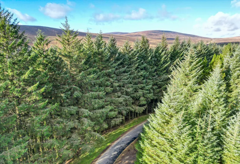
South of Sally Gap, the Military Road continues through more bogland past Lough Dan and eventually descends to Laragh, the gateway to Glendalough. The combination of the Military Road and Glendalough makes a full day from Dublin that covers both mountain and valley.
The honest negative: this drive depends entirely on weather. In fog or heavy rain, you see nothing. The bog is grey, the views are gone, and you are driving a narrow mountain road with poor visibility for no reward. Check the forecast and save it for a clear day. Also, the road is narrow in places with no hard shoulder. Pull in carefully for oncoming traffic. Sheep wander across the road without warning. And there are no petrol stations, shops, or toilets between the Dublin suburbs and Laragh - about 45 kilometres of nothing.
How to Get There
From Dublin city centre, head south through Rathfarnham on the R115. The Military Road starts where the suburbs end, about 30 minutes from the centre. From Enniskerry, take the R760 to join the R115 at Glencree.
There is no public transport on the Military Road. This is a driving route. A rental car is essential. The road is fully paved but narrow in sections. Motorbikes and cyclists also use it, especially at weekends. Allow 2-3 hours for the full drive with photo stops.
Where to Stay Nearby
The Military Road is a day drive, not a base. Stay in Enniskerry for the northern end, Laragh for the southern end near Glendalough. The County Wicklow hub covers all options.
Absurdly grand for a county this close to Dublin. The Sika restaurant is excellent and the views of Sugar Loaf from the terrace are worth the room rate alone.
Check availability →What Else is Nearby
A Note on the History
The Military Road was built between 1800 and 1809 by the British army after the 1798 rebellion. Irish rebels under Michael Dwyer and others used the Wicklow Mountains as a base for guerrilla attacks, and the existing roads could not penetrate the interior. The British built a series of barracks at Glencree, Drumgoff, Aghavannagh, and Laragh, connected by this mountain road.
The strategy worked. The barracks garrisoned troops who could respond quickly to rebel activity, and the road itself removed the cover that the mountains had provided. Dwyer held out until 1803 but eventually surrendered. The barracks are now ruins or repurposed buildings, and the road that was built to suppress a rebellion became one of Ireland's great scenic drives.
Frequently Asked Questions