The Wicklow Way: Ireland's Oldest Long-Distance Trail
The Wicklow Way was Ireland's first waymarked long-distance trail, opened in 1982. It runs 127 kilometres from Marlay Park in the Dublin suburbs to Clonegal in County Carlow, crossing the spine of the Wicklow Mountains through bogland, forest, and valleys. You can walk the whole thing in 5-8 days or pick individual stages as day walks, which is what most people do.
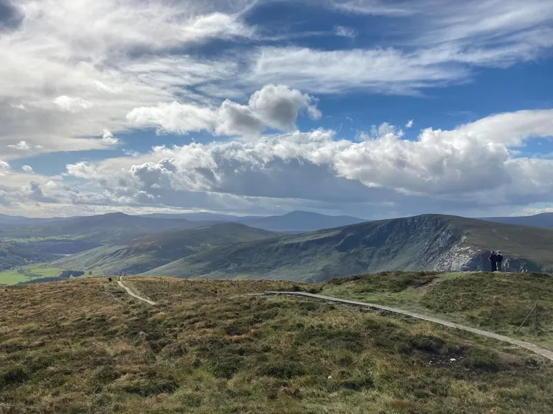
The trail passes through some of the best landscape in eastern Ireland - the Sally Gap moorland, the forests around Glendalough, and the rolling countryside of south Wicklow. It is well waymarked with yellow arrows and posts, moderately difficult, and entirely free. The northern sections are the most dramatic. The southern sections are gentler, through farmland and forest. Most walkers start from Dublin and walk south.
What to Expect
The trail divides into 6-8 stages depending on your pace. The first stage from Marlay Park to Knockree is 20 kilometres through the Dublin Mountains and pine forest. It starts gently and gets progressively wilder. By the time you reach Knockree youth hostel, the city is gone.
Stage two crosses the Sally Gap and the high bog. This is the most exposed section - open moorland with no shelter and no waymarks visible in fog. Navigation skills matter here. The views in clear weather are enormous. The trail passes close to Lough Tay and the Guinness Lake viewpoint, though the trail itself does not go to the famous viewpoint.
Glendalough is the halfway point and the natural rest day. The trail descends into the valley past the Upper Lake and the monastic site. Most walkers stay a night and explore the valley before continuing south. The stage from Glendalough to Glenmalure is through dense forest with a steep climb out of the valley.
South of Glenmalure, the landscape softens. Forest gives way to farmland, the mountains flatten into hills, and the trail follows quiet country lanes between villages. Tinahely, Shillelagh, and finally Clonegal. These southern stages are less dramatic but have their own appeal - the countryside is gentle, the B&Bs are welcoming, and the pace slows.
The honest negative: the Wicklow Way is not maintained to the standard of, say, the Camino de Santiago. Sections through forestry plantations can be monotonous - kilometres of fire road between identical Sitka spruce. The waymarking is generally good but there are gaps, particularly on open mountain. Boggy sections in the north can be ankle-deep in water after rain. And accommodation is limited on some stages - you need to book ahead in summer or carry camping gear. This is a trail that rewards planning.
How to Get There
The northern trailhead at Marlay Park is in Rathfarnham, south Dublin. Dublin Bus routes 14, 15B, and 16 stop nearby. From Dublin city centre it is about 30 minutes by car or 45 minutes by bus.
The southern trailhead at Clonegal has no public transport. Most walkers arrange a pickup or taxi to Bunclody (10 km) for bus connections. For day walks, a car is useful for reaching stage start points, though some northern stages are accessible by Dublin Bus.
Where to Stay Nearby
Accommodation along the trail ranges from hostels to B&Bs. Book ahead in summer. The County Wicklow hub covers options at key stops along the route.
Absurdly grand for a county this close to Dublin. The Sika restaurant is excellent and the views of Sugar Loaf from the terrace are worth the room rate alone.
Check availability →What Else is Nearby
A Note on the History
The Wicklow Way was the brainchild of JB Malone, a Dublin journalist and hillwalker who spent decades exploring and documenting walking routes in the Wicklow Mountains. He campaigned for a network of waymarked trails and in 1982 the Wicklow Way became the first National Waymarked Trail in Ireland. Malone died in 1989 and a memorial stone stands on the trail near the Sally Gap.
The trail passes through landscape shaped by centuries of human activity - monastic settlements at Glendalough, military roads from the 1798 rebellion, lead mines in Glenmalure, and the planned villages of south Wicklow. The Wicklow Mountains were the last stronghold of Irish rebels fighting British rule, and the remoteness that made them a refuge is the same quality that makes them attractive to walkers today.
Frequently Asked Questions